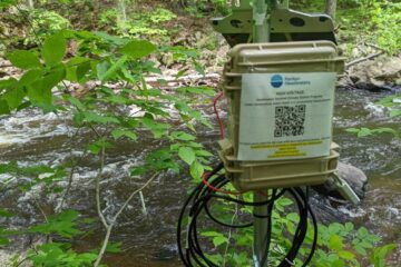
Site Description

Site ID: SB06
Raritan Township, Hunterdon County
Stream Category: FW2-NT (Category 2, Non-trout waters)
Site monitors Raritan River South Branch (Three Bridges to Prescott Brook) subwatershed (HUC: 02030105020100)
The site is located on private property at Darts Mill Campground; property owners must be contacted before the site can be accessed.

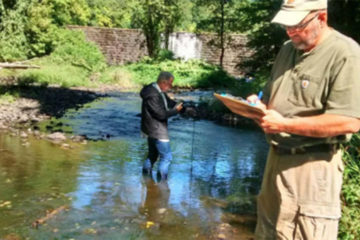
What is being monitored at this site?

  • Biological and Visual Assessments (?)
  • Chemical Testing (?)

Interactive Map: Under Legend, click on layers to turn them on/off. Click on > to view definitions. If a layer is greyed out, use the +/mouse to zoom in to activate. Click on map layers to get detailed information.

Water Quality Data

Each June, Raritan Headwaters scientists and volunteers visit 72 stream sites in the North and South Branch Raritan Watershed Region (WMA8) of New Jersey to collect data on the health of our streams.  Data collected includes a sample of benthic macroinvertebrates (used to calculate the High Gradient Macroinvertebrate Index;HGMI score), an assessment of the habitat in and around the stream, and chemical conditions in the water.  Chemical parameters include dissolved oxygen, phosphate, chloride, specific conductance, nitrate, turbidity, pH, and temperature. The HGMI is used by the NJ Department of Environmental Protection (NJDEP) and the US Environmental Protection Agency (USEPA) to determine if the site is meeting state and national water quality standards under the Clean Water Act. Click here to learn more about our stream monitoring program and water quality reports.


Site Data for SB06

Select a parameter below to view annual data. Hover over the chart to get more information.

Threats and Recommendations

The HGMI at SB06 was found to be good in 2019, which means it was not biologically impaired. This site is located within an agriculturally rich section of our watershed, which means that run off from farm fields as well as lack of riparian buffers are likely negatively impacting the water quality of this stream. Unlike the HGMI, the habitat scored sub-optimal. This site suffers from heavy bank erosion, lack of bank vegetative protection, and insufficient riparian zone width.  Increasing the bank vegetative cover and widening the riparian zone will help to decrease the bank erosion  and increase bank stability at this site.

SB06

SB06

Google Map View

Latest News About Water Quality